Lidar
Road survey tool
Road survey tool
Information & downloads
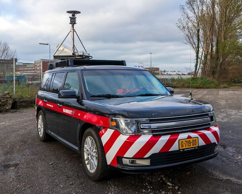
The Mammoet Lidar is a fully equipped survey car, equipped with a LIDAR laser measurement system and a 360 camera. The car is able to map long transport routes, both on public roads and project sites. After scanning a route, we have very detailed 3D data of the environment, a so-called point cloud (point cloud) in combination with accurate location data and 360 colors.
The Mammoet Lidar delivers an efficient, quick, and safe mapping method. it scans the road and its surroundings very accurately (up to 5 mm). Driving at highway speeds and without the need for additional road measurements, there is no disturbance to normal traffic. The quick data processing means clients will have the information they need faster. In addition, it is possible to go back and revisit any space, at any time. Mammoet Lidar will enable you to make decisions fast and based on facts.
Increased safety
When performing measurements on roads and their environment, roadblocks are often required. Apart from the high costs involved, it is a nuisance for road traffic and also increases the risks of accidents. The Lidar visualizes the road and its immediate environment safely and without the need for additional traffic measures.
Collect once, use multiple times
Once the data is collected and processed, it is possible to go back and revisit any space, at any time. Whether it is needed to relook at a given viewpoint or capture a forgotten measurement, it is available 24/7, for everybody.
Added accuracy
Equipped with a world-class lidar sensor, the Lidar scans the road and its surroundings very accurately ( up to 5 mm), making it the perfect fit for most mobile mapping projects.
Quick turnaround
Through smart automation of data processing, clients will have all the information to make those important decisions a lot faster.